The Wanderer
The Larapinta Trail is one of Australia’s iconic long distance hiking tracks, stretching for 223km through the Red Centre’s West MacDonnell Ranges. Even better is the hike through Ormiston Pound. Though it doesn’t form part of the Larapinta, it’s a side route that shouldn’t be missed, traversing a bowl-shaped depression to Ormiston Creek where magnificent gorge walls reaching 300m upwards often reflect the fiery afternoon sun.
Length: 9km
Difficulty: Moderate
Best time: May-September
Highlight: Cooling off in the chilly Ormiston Creek
Tip: You’ll be surprised at how cold that water is.
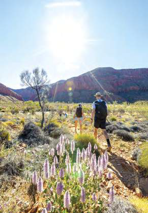
The singularly beautiful West MacDonnell Ranges. Image: Mark Daffey
Park outside the Freycinet National Park Visitor Centre on Tasmania’s east coast and you’ll notice a track zigzagging uphill towards a saddle. That saddle connects Mount Amos with Mount Mayson — two-fifths of the Hazards Range, which you’ll be crossing to reach Wineglass Bay. At the top, a sidetrack leads to a lookout point offering postcard-perfect views over the bay. For many, this is as far as they’ll get. Big mistake! Push on and you’ll descend through shady yellow gum trees to the clearest ocean water imaginable. Dip your toes in before returning the same way.
Length: 11km
Difficulty: Moderate
Best time: November-April
Highlight: That signature view over Wineglass Bay from the lookout
Tip: Bring your bathers.
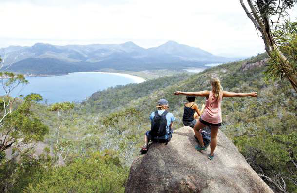
Wineglass Bay’s iconic view. Image: Mark Daffey
The Flinders Ranges start roughly 200km north of Adelaide and extend for some 800km to Lake Callabonna. The jewel in the crown is undoubtedly Ikara-Wilpena Pound, a natural amphitheatre that was once a meeting place for the local Adnyamathanha peoples. The easy way into the pound is through Pound Gap to the Hills Homestead. But better views can be obtained from the top of Saint Mary Peak, the ranges’ highest point at 1171m. Do that and you’ll be richly rewarded with views over the pound and the alligator-back ridgeline of the Heysen and ABC Ranges.
Length: 14.8km
Difficulty: Challenging
Best time: May-September
Highlight: Views from the top
Tip: The steepest part of the trail is just before the Tanderra Saddle.
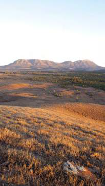
South Australia is out of this world. Image: Mark Daffey
There’s a winter chill in the air as our hiking group commences the gentle climb to the summit of Mount Mitchell in Queensland’s Main Range National Park. Overnight temperatures dipped close to freezing a week earlier and it’s still cool now, despite the clear skies and bright sunshine overhead.
Our guide, Alistair Oakman, leads from the front, pausing often to pass on interesting snippets about our surroundings. Stopping to pick up seedpods resembling exploded grenade casings, he tells us that they belong to native teak trees, or crow ash. There are indigenous varieties of ginger and grape vine, native sarsaparilla, raspberry, and mint. Then he stops beside a hoop pine that’s 40 metres high. Ones like these have been around for hundreds of years, and are distant relatives of Wollemi pines — some of our oldest trees.
“I reckon they give you a pretty good insight into what the world might have looked like when dinosaurs roamed the Earth,” he says.
Steep inclines are always worth it. Image: Mark Daffey
The higher we climb, the more the din from the highway recedes. As we sink further into this World Heritage-listed Gondwana Rainforest, Oakman pauses beside strangler figs whose seeds germinate as bird droppings on higher branches. They then grow downwards, towards the ground, until they eventually suffocate their hosts. Epiphytes and orchids sprout from the trunks of larger trees.
He warns us about the heart shaped leaves of the giant stinging nettle. “They irritate ten times more than ordinary stinging nettles. People have been known to reach for them when nature calls. I’d advise against that,” he says, raising an eyebrow.
Plenty of birds hide in this richly tangled rainforest, and all sorts of unsavoury critters lurk in the mysterious undergrowth. Oakman crouches beside the track, signalling towards the nests of tube spiders and tousled snares of basket weaving spiders. Cleverly concealed beneath a mossy lid is the entrance to a trapdoor spider’s lair that we’d never have noticed on our own.
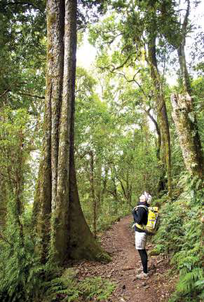
Some of the trees are centuries old. Image: Mark Daffey
In the distance, the shrill calls of Albert’s lyrebirds echo through the forest. A plump yellow robin clings to a tree trunk. Crested whipbirds, and bell miners that have caused motorists on the highway to pull over in the mistaken belief that their brakes are squealing, are constant companions — heard, but never seen.
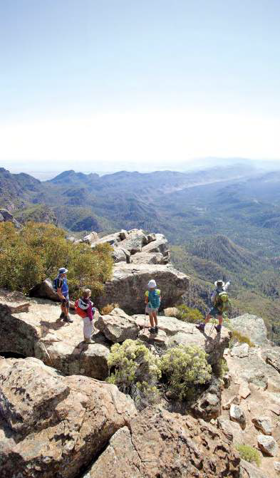
Eventually, gaps begin to appear through the foliage, affording views over the Scenic Rim mountains. After two hours’ of hiking up and around the double-humped Mount Mitchell, we inch towards the summit of the mountain’s East Peak. A savage wind whips across a knife-edge ridge that halts suddenly above a sheer cliff leading down into the Fassifern Valley. Nearby is Spicers Gap, so named by explorer and botanist, Allan Cunningham, when he passed through here almost 200 years ago, opening up a route to the fertile Darling Downs. And across the valley are Mounts Maroon, Lindesay, Barney and Ballow — all remnants from a time when volcanic activity shaped this region. Right now, I couldn’t imagine a more different time.
Length: 10km
Difficulty: Moderate to challenging
Best time: June-August
Highlight: The immediate feeling of relaxation when you put the highway behind you
Tip: Don’t be put off by the fact that it’s a constant uphill walk, as the gradients are mostly agreeable.
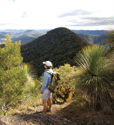
Marvel at the spectacular views. Image: Mark Daffey
Namadgi National Park occupies almost half the Australian Capital Territory’s land area. There are 160km of short and long hikes through alpine meadows and snow gum forest. The trek to the Yankee Hut Shelter cuts through grasslands towards an Indigenous rock art site illustrating dingoes, turtles, and kangaroos.
Length: 6km
Difficulty: Easy
Best time: September-April
Highlight: Indigenous rock art
Tip: Be respectful and don’t touch the fragile rock art — it’s thousands of years old.
Yankee Hat is an easy walk. Image: Visit Canberra
The Blue Mountains, west of Sydney, is peppered with great hikes that can last from a few hours to a few days. If you do only one, make it the National Pass trail from Wentworth Falls. It starts with a sharp, stairway descent into the Valley of the Waters — aptly named for its many gushing waterfalls. Halfway down the trail levels out, following a rock ledge as it passes by, and behind are numerous cascades high above the Jamison Valley. Lookout points are strung out along the way as you shelter beneath sandstone overhangs and wrap around cliff walls to the actual Wentworth Falls, thereafter climbing the Grand Stairway back to the escarpment rim.
Length: 4.5km
Difficulty: Medium
Best time: September-October, following winter rains
Highlight: Hiking down into a valley instead of up to a summit
Tip: Check the weather forecast, as some sections of the track can become impassable after rain.
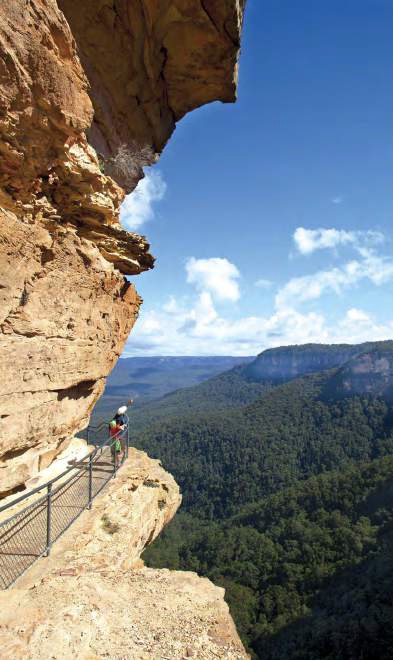
A lookout on the National Pass trail. Image: Mark Daffey
Situated at the mouth of the Murchison River on Western Australia’s Coral Coast, Kalbarri National Park is best known for its new, multi-million-dollar Skywalk and the photogenic Nature’s Window. Both are located inland, overlooking the Murchison River. But the park also contains a rugged coastline that’s best seen during the walk from Eagle Gorge to Natural Bridge, part of which is along a raised boardwalk. Think bizarre rock formations, multi-coloured sandstone cliffs and uninterrupted ocean views. Come in spring and you may even spot migrating humpback whales.
Length: 8km
Difficulty: Easy
Best time: July-September
Highlight: Ocean waves crashing beneath Natural Bridge
Tip: Arrange to be picked up at Natural Bridge to avoid retracing your steps.
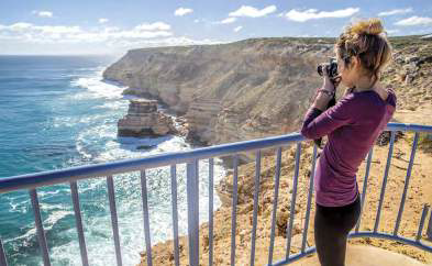
Kalbarri National Park vistas. Image: Greg Snell
The eagerly awaited Grampians Peak Trail has just joined a lengthening list of multi-day walks around the country, but not everyone has a spare 12 or 13 days to go hiking — better to narrow it down to just one section. The Wonderland Range above Halls Gap in western Victoria is the most popular area for visitors, featuring such unusual rock formations as the Nerve Test and The Pinnacle, as well as eerie yet beautiful corridors like the Grand Canyon and the tree-lined Silent Street.
Length: 10km
Difficulty: Strenuous
Best time: Autumn, Spring
Highlight: Squeezing between the canyon walls of Silent Street
Tip: Wear sunscreen — there’s very little shade.
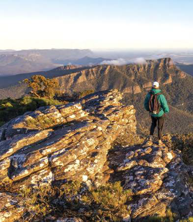
The Grampians is a beautiful place to hike. Image: Mark Daffey
Category: Features
Written: Sat 01 Jan 2022
Printed: January, 2022
Published By:
