The Wanderer
We had explored much of the Limestone Coast, stayed at Robe several times and camped in Little Dip Caravan Park on other occasions. But we hadn’t visited Beachport for a few years so we decided to try camping in Beachport Caravan Park for a number of days in May, 2013.
From Victor Harbor we travelled through Strathalbyn and crossed the River Murray via the ferry at Wellington. We stopped for a break at Meningie on the shore of Lake Albert before continuing onto the loop road past campsites and Tea Tree Crossing. The usually good, unsealed road was very corrugated! The melaleuca and acacia bushes all looked good, and the samphire and grasses around the lakes were thriving, but the lakes themselves had very little water. We had seen them full and alive with many species of birds previously, but not on this trip.

Wonderful shapes
We headed back on to the bitumen briefly, then onto the unsealed Old Melbourne Road. This road passes several crossings over to the other side of the Coorong and old campsites which were closed. The only birds sighted along the way were emus but we were surprised to see a pale coloured deer! We re-joined the bitumen near Kingston after passing the Granites, several rounded outcrops right on the beach. Kingston is always worth a visit as it has many attractions and a very good bakery. We priced lobster but are still waiting for a very special occasion!
We drove into Cape Jaffa to see how the ‘new’ marina was developing and were surprised at the lack of boats and slow growth. Robe was next and as usual the main street was busy. We visited the cliff top obelisk and wondered how long it will remain, as the surrounding cliff is gradually eroding away.
We called into Little Dip Caravan Park and a previous campsite at Old Man Lake. This small Lake was full and the campsite empty but for the blue wrens. There were four or five campsites there, none suitable for caravans, and a basic earth toilet. Despite the ‘gas fires only’ sign, there was ample evidence of campfires! We stayed on the gravel and passed the turn off to Nora Creina, a fishing village on private land on the shore of a beautiful little bay. Well worth the detour if you have time.
It was still early afternoon when we rolled into Beachport and found the right road into the caravan park and 3 Mile Campground on the edge of Lake George (I remembered there being two camping areas on a previous visit). We found a great site protected on three sides by melaleucas and set up our camper trailer. We checked out the other five designated sites and found only one was occupied.
We walked the short distance to the edge of Lake George and although the water was some distance away we could see (and hear) hundreds of swans, ducks and waders. This Lake is an important stop on the migratory birds’ highway and during winter, when full, is a birdwatchers paradise.
The bitumen ends at the Conservation Park’s boundary, which is only two kilometres from Beachport. The mainly good road then follows the edge of the Lake. You can drive right around, but 4WD is advisable for parts, especially if there has been rain. When the water level is low you can drive on the Lake surface but I think 4WD would again be a good idea. We decided to explore further and followed the main track into the Park where the water was closer to the track. We sat with our binoculars and camera on an informal boat ramp that is used for windsurfers and sailboats when the Lake fills.
We headed back to camp for happy hour and to cook dinner but we were invaded by a large cloud of midges that tried to share our food and drinks! We had to cover our still uncooked meal and retreat to our tent with our drinks and nibbles. They moved on when darkness fell but by then we were considering making this a one night stay!
The next morning we followed the Lake edge track back towards Beachport. Old tracks leading away from the edge into the melaleucas had been fenced off. We walked into one and found cleared areas that had been campsites in the past. Walking back to the Lake edge we found a recently used, undesignated camp that was full of glass and plastic bottles, as well as the bags used to carry them in! We packed up as many as we could and took them out to the track so we could return in our vehicle and collect them. We later returned, loaded up those and more that we found, and took them into Beachport for disposal.
Later, we drove to Southend and looked at campgrounds in Canunda National Park. The three we found had mainly small sites but there were a couple large enough for our camper trailer. This Park is a truly beautiful place. We walked part of the Seaview Walking Trail, which took us along the cliff tops looking out to the Southern Ocean. This coastline rivals the Great Ocean Road but without the car parks and people. We were intrigued a several places along the cliff edge to find old rusted iron posts set in shapes that suggested boat moorings or sheds but with no access except from the sea. We could see no other clues to their former use. Most of the way along the trail there were extensive midden heaps of shells from the time when this coast was a very important part of the Aboriginal lifestyle.
Curved Jetty at Southend
We had a drive around Southend, another small town with a history of whaling and fishing. Southend is still an active working port. The jetty is an unusual curved structure with a rail track in situ for bringing in the crayfish catch. There are two caravan parks, one with a separate bush camping ground close to the beach. We returned to our camp and decided that if the midges stayed away we would stay on.
The next morning, after enjoying the previous night’s dinner with no ‘guests’, we drove to a small freshwater lake close to the main track. It had plenty of water but there were only a few wood ducks, shelducks and banded stilts in residence. On our way back we found the other campsite that we remembered, very overgrown and fenced off with a ‘temporarily closed’ sign.
We ended up stopping at Woolley’s Lake. There is a marked walking trail around the Lake where many plants are identified. The view from the lookout was very impressive but unfortunately the Lake was dry. The walk was pleasant; partly through a melaleuca grove and then eucalyptus forest.
After lunch we walked next door to the museum in the old wool and grain store. The train that was used on the jetty would come into the building for servicing; the line and pit are still there and the smoke stains are still apparent above the door. The railway station is now the town’s bowling club.
Among the many interesting exhibits there was a huge bulldozer used to build airfields in the Pacific Islands during WW2. A room of information boards tells the moving story of the Buandik people, the Aboriginal people who lived in this area before white settlement. Upstairs was built as accommodation and has been restored and furnished as it would have been in the 1900s. There were many exhibits showing the agricultural and fishing heritage of the area. The volunteers who run this excellent museum were helpful and are very proud of their town.
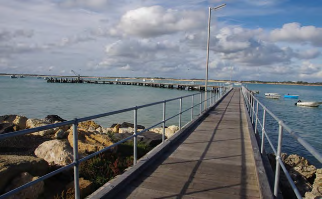
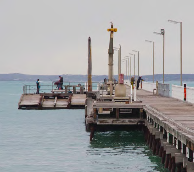
We decided to walk out along the one kilometre Screwpile Jetty. This is the second longest jetty in SA. It is quite unusual as there are several lower platforms along its length and a boat slip at the end. After a bracing walk (the weather had become grey and windy) we drove out along the tourist drive to a lookout above Penguin Island, the site of the original lighthouse. There also used to be homes for two keepers on the Island but these were demolished in the 1930s.
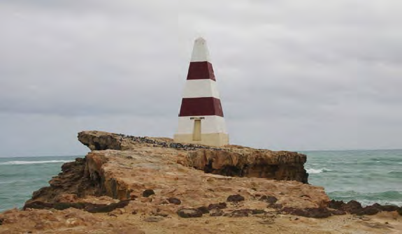
Beachport Obelisk, note the erosion of the cliff
Back at camp we found we had neighbours – two motorhomes parked a good way from our site The next day we headed off for Millicent, and after a quick look around, drove out to Canunda National Park. We visited Oil Rig Square and the campground at Geltwood Beach; there were several sites available but they were only suitable for tents.
Coola Outstation has an interesting history and walking trail, and is close to Lake Bonney. On the drive there we passed a newly burnt area, part of the National Parks’ burn off program to reduce woody weeds and regenerate the grassy interdune areas. We found the trail-head and followed it to the lookout. Lake Bonney from there looked empty and the signs we passed warning of floating logs would appear to be redundant! The walk then led us to a raised boardwalk over what would normally be a wetland after rain but was a large area of reeds at the time of our visit. We continued on, up and over another sand hill, passing a few artefacts from early farming days. One was a ‘bait layer’ for rabbits – obviously pre-myxomatosis. We finally reached the Outstation ruin, it was a stone building that had a wooden frontage. This has now gone but the substantial stone walls are very impressive. The outbuildings have long since gone but the original cypress hedge has become a series of huge cypress trees. We returned to our vehicle and drove to the edge of Lake Bonney and found all that remains of the wooden motor boat Airlie.
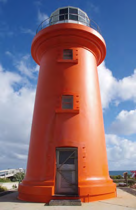
Cape Banks Lighthouse
We thought we would have lunch at Carpenter Rocks, so drove back to the bitumen and headed south. We came to a huge wind farm, the largest we had ever seen. Many of the turbines were very close to houses, but these appeared to be empty, so we can only assume they must have been purchased by the operator. We decided to follow a gravel road which looked to be a direct route to Carpenter Rocks. It did connect but definitely not directly. We lunched looking over the small bay at Carpenter Rocks, but it was cold and windy so we drove on to Cape Banks Lighthouse. This is a fully automated working Lighthouse. There were lovely views of the coast from here and an interesting series of information boards telling the story of a shipwreck that occurred off the Cape. We checked out the campground, but only a few sites and one ‘long drop’ toilet were available.
We headed back to camp via some pretty back roads and through Tantanoola, famous for the tiger that was reputed to roam the district. We stopped at Lake Frome for a cuppa. This would be a lovely place in a wet year, but the Lake was dry and the walking track around the Lake to the bird hide was not maintained. Back at our camp we found that the motorhomes had moved on, we would have liked to chat to them and see how they were enjoying their mode of travel as we were planning on buying one ourselves.
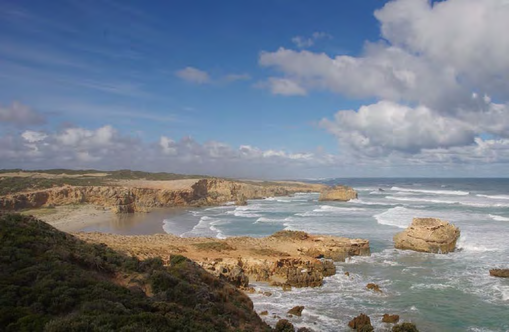
Coastline that rivals the Great Ocean Road
The next morning we drove over to Penola. We had stayed there previously and explored the district several years ago with fond memories of the town and nearby Coonawarra wine region. On the way we found the Kangaroo Inn ruins which have been preserved. One room with a roof contains info boards detailing the history of the buildings, including a story of a murder committed during the digging by hand of the Reedy Creek Drain.
We stopped in Furner to photograph another old inn and were greeted by the town dog, which jumped up in our vehicle, and would have cheerfully gone travelling with us. We then stopped at Penola Caravan Park for morning tea. This is a lovely little park with a boardwalk through a wetland area and a loop walk with interpretive signs for birds, plants and animals. Unfortunately the area was very dry at the time.
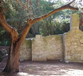
Ruins of Coola Outstation
Reaching Penola, we took a short drive down Petticoat Lane, to refresh our memories of our stay in one of the ancient cottages on our last visit. We parked in the main street and browsed the antique shop’s unusual offerings. Later we visited several wineries including the historic Wynn’s. The buildings had been beautifully restored and a huge tasting room had a display of artefacts and memorabilia from the winery.
We returned to camp and sadly decided that we would have to return home the next day.
Category: Unknown
Written: Tue 30 July 2013
Printed: August, 2013
Published By:

Bruce & Helen Williams N77000