The Wanderer
The Tasmanian Wilderness World Heritage Area (TWWHA) embraces six national parks plus other conservation areas that jointly cover more than 1.5 million hectares, one-fifth of Tasmania’s land mass. It is one of the few remaining temperate wilderness areas on the planet, sharing that honour with the Fiordland region of south-west New Zealand and the Patagonian Andes of South America, all united in evolutionary history on the ancient supercontinent of Gondwana.
The area was inscribed on the World Heritage List in 1982 because it conserves a diverse array of natural and cultural features of outstanding global significance. Despite its wilderness, visitors can access several locations in southwest Tasmania that demonstrate why the area is so special, including Lake Pedder, where modern environmental activism began, and the Styx Valley, where the battle to protect old growth forests continued for decades after.

Teds Beach near the Lake Pedder campground
LAKE PEDDER — BIRTHPLACE OF GREEN ACTIVISM
Environmentalists have been active in Australia since the 1860s, but it wasn’t until the 1960s and ‘70s that the modern conservation movement was born amid political agitation for women’s liberation, Indigenous land rights and the end of the Vietnam War. During these decades, the push to protect Australia’s rich environmental heritage shifted from polite backroom persuasion to sometimes violent confrontation in the bush and city streets alike. A major catalyst for this paradigm shift was the campaign in Tasmania’s south-west wilderness to save Lake Pedder from inundation by the state’s Hydro-Electric Commission.
Glaciation over many thousands of years deposited debris on the plains between the Frankland and Coronet Ranges, creating a natural dam behind which a shallow lake formed and fed the Serpentine River. During the drier summer months, the lake shrank to expose a distinctive pink quartzite beach. In 1835, while on an expedition to find the source of the Huon River, surveyor John Wedge named the lake after the colony’s first Chief Justice, Sir John Lewes Pedder. It received few visitors over the next hundred years until, in the 1940s, light planes began landing sightseers on Pedder’s broad beach. In 1955, the glacial lake and its surrounds were declared a national park.
Lake Pedder from Red Knoll Lookout
Subsequently, the State’s Hydro- Electric Commission (HEC), with staunch support from Tasmania’s Premier, Eric Reece (aka ‘Electric Eric’), devised plans to develop Lake Pedder as a site for harnessing some of the area’s 2.5m of annual rainfall for hydro-electricity. The scheme involved constructing a series of dams, the major one being over the Gordon River, that would create Lake Gordon and inundate Lake Pedder. To enable the scheme, the region’s national park status was revoked and, in 1967, construction began on the 72km access road from Maydena to Strathgordon. This sparked a seven-year protesting campaign.
Ultimately, the campaign failed but it led to the formation of organisations such as The Wilderness Society, Greenpeace and the Australian Conservation Foundation, and laid the ground work for the Tasmanian Wilderness World Heritage Area (TWWHA). It also marked the genesis of the world’s first environment-based political party, the Australian Greens, which has, at times, held the balance of power in the Australian Senate.
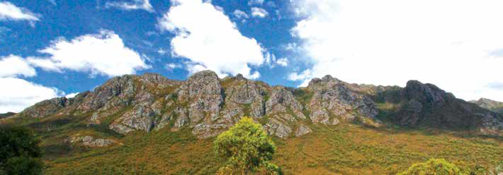
The Needles make a spectacular backdrop
PAYING HOMAGE TO AN ICON
The Gordon Dam is 170km west of Hobart, where the South West National Park adjoins the Franklin- Gordon Wild Rivers NP. It is accessed by a sealed road that provides a scenic drive through a landscape of jagged mountain ranges, rolling button grass plains and pristine forests.
After leaving the Lyell Highway (A10) near New Norfolk, the Gordon River Road (B61) skirts the Mt Field NP to begin its course westward. The tiny village of National Park sits on the doorstep of Mt Field where the Land of the Giants Campground makes a handy base from which to explore the south-west region. Beyond Mt Field the B61 shadows the beautiful Tyenna River through a forested valley with occasional glimpses of the serrated skylines of distant ranges.
At Frodsham Pass, Scott’s Peak Road (C607) branches south on a good gravel surface. After a short distance, it comes to the Creepy Crawly Nature Trail, where a boardwalk provides a 20-minute stroll through a cool rainforest of vine thickets, moss-covered logs and gnarly trees with lichen-draped branches. As it penetrates deeper into the South West NP, the C607 passes the dolerite peaks of Mt Anne (the highest peak in the south-west), Eve Peak and Mt Eliza, with superb views of the surrounding ranges.
After 30km travellers arrive at Edgar Dam, constructed by Hydro Tasmania (Hydro) as part of the Gordon River Power Development Scheme. Together with Scott’s Peak Dam and Serpentine Dam, it retains the Huon-Serpentine Impoundment (aka Lake Pedder), the biggest water storage system in Australia.
The Edgar Campground (managed by Hydro) is the larger of two camping areas at the southern end of the lake, with about 20 spacious sites. Although relatively exposed, its close proximity to the dam, sweeping vistas across eastern Lake Pedder and a readily accessible boat ramp make it a popular venue for anglers. It’s a free camp with toilets, showers, fireplaces and a basic, but sunny, kitchen shelter.
A few kilometres past Edgar Dam lies the secluded Huon Campground, managed by Tas Parks. It has about 10 sites (some suitable for vans) tucked away in a forested area below Scott’s Peak Dam, offering good protection from the elements. Facilities include a shelter, composting toilets and fireplaces (firewood provided). There are no charges and bookings are not taken. The trailhead for the Port Davey and Arthur Plains track is close to the campground, making it a convenient waypoint for trekkers. A short drive to nearby Red Knoll Lookout affords stunning panoramas over Lake Pedder and across the button grass plains to the distant ramparts of the Arthur Range.

The pondage below Edgar Dam
From Frodsham Pass, the Gordon River Road traces a sinuous route westward, skirting the Sentinel Range for about 44km to Strathgordon. It is a spectacular journey, with strategic lookouts and viewing bays along the way. Sheltered picnic areas and fireplaces (no camping) at The Needles and Wedge River provide great spots to relax in a bush setting with mountain views.
Three kilometres short of Strathgordon, Teds Beach Campground is situated on the shores of Lake Pedder. The upper section of the camping area is fairly level with a limited number of sites without lake views. The rest of the campground has views over the lake but slopes down to the beach, so setting up your rig may require some tweaking. Facilities include toilets, showers and electric barbecues, and the broad, gently sloping beach makes a natural boat launching area.
Strathgordon was created to house HEC employees during the construction of the Gordon Dam. Power station workers still live there, and the Hydro Tasmania Visitor Centre provides information about the dams, two huge models of the power station and 3D maps of the lakes and surrounding mountains. About 2km beyond the village is the Lake Pedder Lookout with expansive views and interpretive signs.
For 12km beyond Strathgordon, the rollercoaster road hugs a ridge overlooking Lake Gordon to the dam wall — a surprisingly thin double arched blade of concrete, 192m long and 140m high (the highest commercial abseil in the world), spanning a grey granite ravine carved over millennia by the Gordon River. This is the tallest dam in Tasmania, impounding the inky waters of Australia’s largest lake. Downstream, the Gordon River continues its ageless passage, snaking another 30km through the heart of the Wild Rivers NP, joining the Franklin River on the way to the Southern Ocean at Macquarie Harbour.
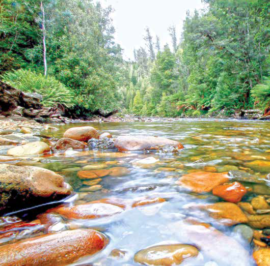
The limpid waters of the Styx
THE STYX — VALLEY OF THE GIANTS
Near Maydena, 15km west of National Park, a minor unsealed road leaves the Gordon River Road heading south on a labyrinthine tour of the mountainous country surrounding the Styx River and the Valley of the Giants. This is one of the best scenic drives in Tasmania, with impressive views of the Maydena, Jubilee and Snowy Ranges. But exercise caution: this is a ‘working forest’ on weekdays and travellers need to be alert for logging trucks and service utes.
Lying at the eastern edge of the TWWHA, these ranges experience a cool temperate climate with an annual rainfall of up to 1500mm, ideal conditions for the tall eucalypts that flourish here. In this, the Styx is unique for its pristine, old growth forests of the world’s tallest flowering plant, ‘King of the Eucalypts’. Known locally as swamp gum or mountain ash, these titans reach heights in excess of 90m, second only in size to the California redwoods.
Many of the Styx giants are more than 400 years old and preside over forest that once covered much of south-east Australia before white settlement. But logging, land clearance and climate-driven wildfires have reduced these forests by an estimated 87 per cent, leaving the Styx as one of the few remaining strongholds. The depletion of these primordial forests continues in the face of commercial logging, which is the main economic activity in the Styx Valley. The replacement forests are plantations of softwoods and eucalypts that do not occur naturally in the Styx, or eucalypt regrowth on a 25–80-year rotation cycle that produces neither tall trees nor rainforest. Within a few generations, the pockets of old growth forest could cease to exist.
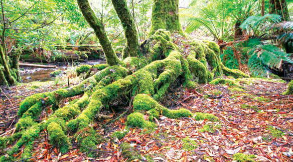
Mosses thrive in the cool temperate environment
Throughout the valley, small reserves have been established to protect some of the largest trees. One is ‘The Big Tree’, measured in1957 at 98m but reduced by natural ageing to a last recorded height of only 86m (2001). Although it has been surpassed in height by other trees in the Styx State Forest, this one is recognised by the National Trust of Tasmania and registered as a ‘Significant Tree’. In this reserve, a boardwalk has been constructed to provide an easy circuit through the forest, and a timber vestibule with specially reclined seating enabling a better view of ‘Big’ in all its towering glory. A short distance further along the circuit stands ‘The Bigger Tree’, which is captivating in its sheer size (87m) and beauty.
Further along Styx Rd, a turn on to Waterfall Creek Road leads to Morannon (the ‘Black Gate’), at the head of the Tolkien Track, which snakes through a moss-covered forest to the twin trunked ‘Fanghorn’ (75m). From here, gnome-like green signs usher the way to the ‘Cave Tree’, the ‘Felled Giant’ and the awe-inspiring ‘Gandalf’s Staff’ (84m).
During the summer of 2003–4, Gandalf’s Staff hosted the Global Rescue Station, a ‘tree-sit’ by Wilderness Society activists suspended in the canopy 65m above the ground, to protest the logging of Tasmania’s ancient forests. The tree became a symbol of old-growth heritage and the focus of national and international media attention for five months. Their efforts won a reprieve for the tree and the permanent reservation of 4,500 hectares in the Styx State Forest for the expansion of the Big Tree Forest Reserve and the creation of the Tall Trees and North Styx Forest Reserves.
In another part of the valley stands the ‘World’s Tallest Christmas Tree’. For two weeks in December 1999, Wilderness Society climbers battled gale force winds and sleet to decorate this 80m regnans with 3000 fairy lights and an enormous star made from a dozen fluorescent tubes. In the glare of international media attention their actions succeeded in preventing the logging of the tree’s forest precinct, which is now protected and remains a poignant reminder of the giants that have been harvested elsewhere.
Camping beside the Tyenna River
THE WRAP
The momentous events that shaped the origins of environmental activism have since passed into history but they serve to remind us that southwest Tasmania is a special place, a legacy from ordinary people who believed, strongly, that such places should be conserved for future generations. Their actions have made it possible for us all to enjoy this precious landscape. For an intrepid minority (in numbers that grow annually), the remoter parts offer the challenge of eco-adventure by trekking, rafting, canoeing and climbing. But many parts of this iconic wilderness can be easily accessed by visitors of all kinds — sightseeing day-trippers, bushwalking families or get-away-from-it-all campers — to pay homage to this world heritage wonderland.
Fast Facts
LAKE PEDDER
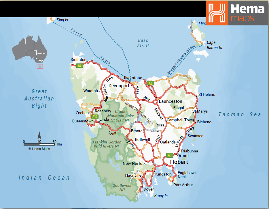
• Gordon Dam is 170km west of Hobart via the Lyell Highway and Gordon River Road.
• From Frodsham Pass, the unsealed C607 to Scotts Peak and the Huon and Edgar Campgrounds.
• The South West NP is a year-round destination but weather in the region can change drastically and suddenly.
• Fuel and supplies are available at New Norfolk, Westerway and Maydena. Fuel is not available west of Maydena.
• Free basic camping is available at Edgar Dam and within the South West NP at Huon and Teds Beach Campgrounds, where camping and park entry fees apply. Anglers need a licence from the Inland Fisheries Service.
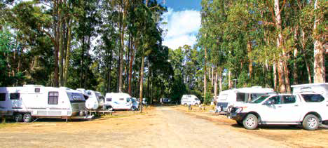
• Camping (including powered van sites) and amenities are also available at the Land of the Giants Caravan Park at Mt Field National Park, 13km east of Maydena. Fees apply and a parks pass is required.
• A range of alternative accommodation is available at Strathgordon (Lake Pedder Chalet), Maydena, Tyenna and New Norfolk.
PARKS & WILDLIFE SERVICE
Field Office (Mt Field and Southwest NPs)
P: (03) 6288 1149 (7 days)
W: parks.tas.gov.au
LAKE PEDDER CHALET
Strathgordon
P: (03) 6280 1166
E: enquire@lakepedderchalet.com.au
TASMANIAN WILDERNESS WHA EXECUTIVE OFFICER
P: 1300 827 727 (weekdays 9am-4:30pm)
E: admin.PWSGM@parks.tas.gov.au
STYX VALLEY
• The Styx Valley is 90km west of Hobart, accessed by Styx Road from a junction on the Gordon River Road about 2.5km west of Maydena.
• The unsealed forest roads are suitable for two-wheel drive vehicles in dry conditions. Be alert for logging trucks and forestry service vehicles that share the tracks.
• No permits are required to travel in the Styx forests but anglers will need a licence from the Inland Fisheries Service.
• The Styx Valley is a year-round destination but weather in the region can change drastically and suddenly at any time of the year.
• Fuel and supplies are available at New Norfolk, Westerway and Maydena (where the opening hours and supplies are limited). Fuel is not available west of Maydena.
• Camping (including powered van sites) and amenities are available at the Land of the Giants Caravan Park at Mt Field National Park, 13km east of Maydena. Fees apply and a parks pass is required.
• Basic camping with limited facilities is also available in the Southwest National Park at Teds Beach, Huon and Edgar Campgrounds. No camping fees apply at Edgar but fees apply and a parks pass is required in the national park.
• A wide range of alternative accommodation is available at Strathgordon (Lake Pedder Chalet), Maydena, Tyenna, Westerway and New Norfolk.
LAKE OF THE GIANTS CARAVAN PARK
Lake Dobson Rd, National Park
P: (03) 6288 1526
PARKS & WILDLIFE SERVICE
Field Office (Mt Field and Southwest NPs)
P: (03) 6288 1149 (7 days)
W: parks.tas.gov.au
FORESTRY TASMANIA
P: 1800 FOREST
W: forestrytas.com.au
Category: Features
Written: Thu 01 Oct 2020
Printed: October, 2020
Published By: